 |
| 2461 |
| DuPont Map |
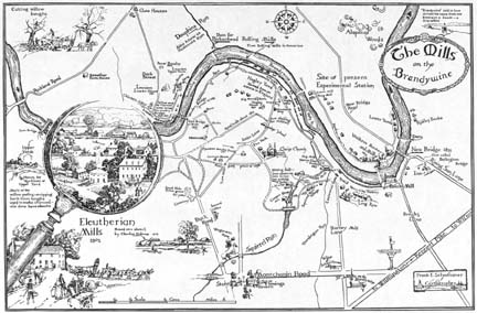
| FES Title: | A Map-for use as Lining pages, Anniversary-150 Years DuPont Co. | |
| Alternate Titles: | ||
| Date: | 02/1952 | |
| Size: | 28″H x 40″W | |
| Medium: | ||
| Type: | illustration | |
| Published: | E.I. du Pont de Nemours and Company. DuPont: The Autobiography of an American Enterprise. New York: Scribner’s Sons, 1952: lining pages. caption: The Mills on The Brandywine Schoonover, Cortlandt. Frank Schoonover, Illustrator of the North American Frontier. New York: Watson-Guptill Publications, 1976: 44. Hayward, Ethel Luella Jones. My Brandywine Valley. Privately printed, 1985: cover. Guide to Winterthur Museum & Country Estate. Winterthur, DE: Winterthur Publications, 2005: 10. Kinnane, Adrian. DuPont From the Banks of the Brandywine to Miracles of Science. Wilmington, DE: E.I. du Pont de Nemours and Co, 2002: front lining pages.[no caption] |
|
| Inscription: | lr: Frank E. Schoonover / Cartographer / ’52 | |
| Annotations: | ||
| Exhibitions: | ||
| Comments: | index;edit; 600dpi image from John A print run of this map was made after the publication of the map as the lining pages for the DuPont book. Schoonover signed a number of maps and gave them as gifts as well as sold them. The location of the original is not known, but the original’s size was 28″ x 40″ and the printed size is 11″ x 16″ (day books). |
|
| Commentary: | Schoonover describes this map as ” A Map – for use as Lining pages – Anniversary – 150 Years DuPont Co. Nov. 28th – 1951- Tom W. Stephenson – Mr. Hackett of Public Relations Department in studio to talk over possibility of Map locating DuPont Mills as of 1802, and other mills along Brandywine [River] as well as homes – bridges – roads- paths – main highways-” Evidently an agreement was reached and the artist writes about gathering materials and completing sketches and preparatory drawings in December and January. During January and February he had “several visits from Stephenson and Hackett to inspect the progress of map. In February, he completed the “Final pen and ink drawing made on Hermusa 28 x 40 paper (from Weber Co.)” (day books) On March 17th he made the final delivery of the map. |
|
| Provenance: | Commissioned by E.I. duPont de Nemours Company, Inc., Wilmington, Delaware (1952); not known | |
| Current Owner: |


